


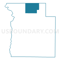
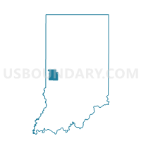
SUGAR CREEK, Parke County, Indiana
About
Outline

Summary
| Unique Area Identifier | 580002 |
| Name | SUGAR CREEK |
| County | Parke County |
| State | Indiana |
| Area (square miles) | 24.91 |
| Land Area (square miles) | 24.89 |
| Water Area (square miles) | 0.02 |
| % of Land Area | 99.94 |
| % of Water Area | 0.06 |
| Latitude of the Internal Point | 39.92755420 |
| Longtitude of the Internal Point | -87.21081220 |
Maps

Graphs
Select a template below for downloading or customizing gragh for SUGAR CREEK, Parke County, Indiana


Neighbors
Neighoring Voting District (by Name) Neighboring Voting District on the Map
- HOWARD, Parke County, IN
- JACKSON, Fountain County, IN
- LIBERTY, Parke County, IN
- MILL CREEK, Fountain County, IN
- PENN, Parke County, IN
Top 10 Neighboring County Subdivision (by Population) Neighboring County Subdivision on the Map
- Millcreek township, Fountain County, IN (1,406)
- Penn township, Parke County, IN (810)
- Liberty township, Parke County, IN (739)
- Jackson township, Fountain County, IN (628)
- Howard township, Parke County, IN (341)
- Sugar Creek township, Parke County, IN (322)
Top 10 Neighboring Unified School District (by Population) Neighboring Unified School District on the Map
- Southeast Fountain School Corporation, IN (7,098)
- Turkey Run Community School Corporation, IN (3,937)